Had enough winter yet? The weather in Portland has been harsh lately, turning a simple trip to your neighborhood New Seasons into an Iditarod-style feat of daring and determination.
But for those special souls who snowshoed to the pub and found that it only whetted the appetite for snowshoeing in the Cascades, we've got five great winter hikes.
A few of these are pretty serious—like, crampons and ice caves—and a few are not, but all are rewarding in their own way.
Related: The Best Hikes Along the Northern Oregon Coast

Distance: 3.6 miles
Difficulty: 
Directions: From Portland, head east toward Mount Hood, through Sandy and past the Timberline Lodge turnout. Soon you'll see a sign on the right side of the road that reads, "Trillium lake .5 mile." Turn right and park in the lot.
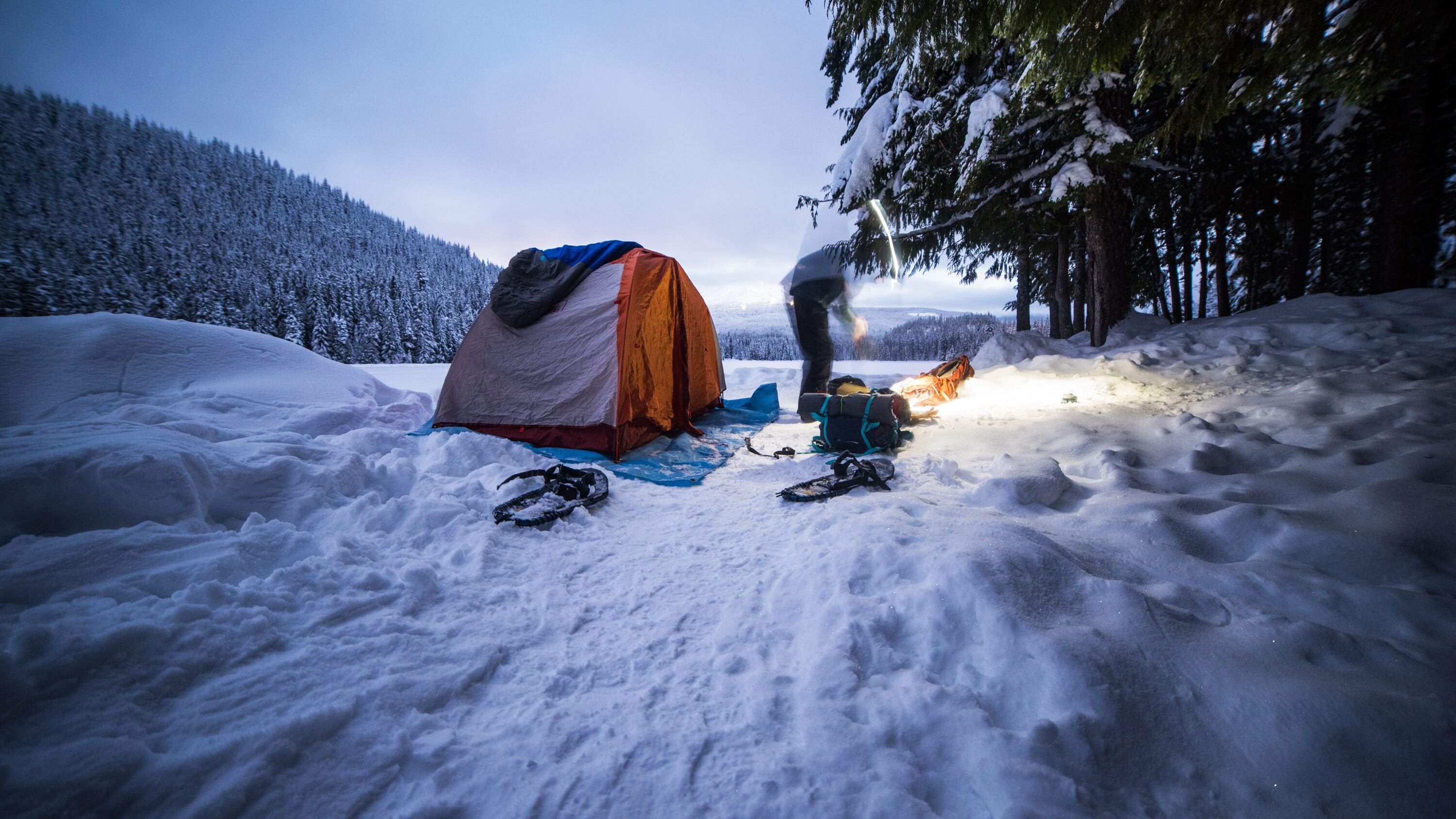
I know what you're thinking. "Isn't Trillium Lake the place overrun by hordes of tourists? The Voodoo Doughnut of the Oregon outdoors?" Well, yes and no. Come November, when the main gate closes and the 1½-mile road to the lake becomes inaccessible by car, the mob dies down and the park turns into a quiet winter wonderland.
Before you go, make sure to grab a pair of snowshoes. Once past the gate, you'll snowshoe on the main road for about 1½ miles under tall evergreens weighed down with snow and the occasional chickadee swooping overhead. The road goes downhill for about a half-mile and then flattens out, great for cross-country skiers looking for a weekend workout. After just over 1½ miles, the trees clear and the lake—which looks more like a snow-covered valley in the winter—appears to your right. If you're feeling brave and the idea of a cold night doesn't send shivers down your spine, this is a great place to camp, with restrooms nearby and great views of Hood and the dock. If an afternoon walk is all you're looking for, continue across the small bridge. The Trillium Lakeshore Trail will be on your right, just after the camping area on your left. Follow that for the remainder of the hike. You'll weave in and out of trees and clearings, past small campsites, and after about a mile, you'll find yourself at the main campground, which connects back to the main road.
0 of 4


Related: Seven Great Fall Hikes Around Portland
Distance: 1.6 miles to Pittock Mansion and back
Difficulty:
Directions: From downtown, head west on Burnside Street for just under 2.5 miles. You'll find the turnout on the right, about 1,000 feet after Northwest Hermosa Boulevard. The trailhead for Pittock Mansion is on the opposite side of the road.
When Portland goes into hibernation for 3 inches of snow—and the Gorge is off limits because of bad road conditions—what is a Portlander to do? Seek adventure on the Wildwood Trail!
You'll find that most roads around Forest Park are shut down during so-called "snowstorms," so to make it easy on drivers, find the Wildwood Trailhead along Burnside.
The low-hanging winter sun floods the park with light, made even brighter on a snow day. The only folks you'll find trekking the path will be other brave, bundled-up adventurers. Keep trucking a short way up to Pittock Mansion, crack open some beers, and watch from above the madness that is Portland in the snow.
From the mansion, the trail continues down toward Balch Creek, passing Northwest Cornell Road and the Witch's Castle. Thin, mossy deciduous trees line the path as you climb up and down Forest Park's ridges and valleys.
Trail-running is a must here, especially in the soft snow. Turn back when you feel satisfied or, if you're feeling exceptional, keep going all the way to Wildwood's end, some 30 miles.


Distance: 1.6 miles round trip
Difficulty: 
Directions: Head to Vancouver and then east on State Route 14 for 35 miles. You'll see the spouting tower rise far above the highway a few hundred feet before you arrive. Pull over to the marked parking lot.
Five miles southwest of Cascade Locks lies a true gem of the gorge: Beacon Rock. Climbed year-round, Beacon Rock, named for its brilliant, prominent stature, jets up nearly 1,000 feet. The monolith, which sits right on the Columbia, was originally named by Lewis and Clark and can be climbed in less than 30 minutes. In 1915, Henry Biddle bought the volcanic plug for $1 and spent the next few years creating the hiking trail that consists of more than 50 switchbacks.
Before you go, be prepared to pay the U.S. Forest Service fee of $10 in cash. There's a less official parking lot just west of the main one, but don't be fooled, you'll still have to pay the fee. The trailhead is between those lots.
Winter is arguably the best and most beautiful time to hike Beacon Rock, when winds are strong and fog rolls in and out as fast as the river. While weaving up through crevices dug into the side of the rock, on slippery metal platforms that hang dizzyingly more than hundreds of feet in the air, you'll have to be careful, and brave. Although it may be slick, the rain keeps people away and makes for vibrantly colored displays, at least once the fog passes.
Once at the top, you'll have brilliant views of the Columbia and the mountains that make up Oregon's side of the gorge. Read the plaque to learn about the Gorge's geological history, and on your way down, be sure to check out the lichen and fungi that thrive on the dampened walls of Beacon Rock.


Distance: 2 miles round trip
Difficulty: 
Directions: From Portland, it takes a 1.5 hours to get to the trailhead. Head south on I-5. Take Exit 282A toward Canby. Turn left onto Oregon Route 211 (Woodburn-Estacada Highway) and travel about six miles. Turn left on South Kropf Road. Head through Marquam, following signs toward Scotts Mill. From Scotts Mill, take Crooked Finger Road past the county park and continue for about 10.5 miles. You'll pass Camp Dakota, and after 2 more miles, the unmarked road to the trailhead will be on your right. A large memorial cross sits at the side of the road a few hundred yards away. Less than a mile down the road, there's a dirt parking area on your right. If you have a sedan or any other car that can't handle gnarly terrain, park here. If you think you can manage, take the rock-covered, pothole-filled road to the trailhead, about a mile down.

Abiqua Falls, made famous on Instagram for its perfect symmetry and clean-cut basalt amphitheater, is a hike attempted by many but seldom completed. That may be because of its remote and confusing location, or its terrifying loose-gravel cliffs that must be carefully traversed with ropes to get to its end, less than 1 mile from the trailhead.
If it's been cold in the Cascades, you might catch the falls completely iced-over. Make sure to bring plenty of warm, waterproof gear as well as crampons or shoe chains. You'll find the trailhead just before the road's end on the left. A sign at the trailhead explains that you're now entering private land, legally; follow that down and keep left, through the thick, fern forests and around moss-covered trees until reaching the first trail drop.
The drop is not a terribly difficult procedure if you're sure-footed; plus, someone's added a rope to make your life easier. Once you've made it safely down, turn left and head up the river along the shore. A roar will begin to buzz in your ears. Soon enough, you'll turn the corner and enter into the massive cavern with Abiqua placed perfectly at its center. Kick back, feel small for a minute, and build a cairn while relaxing in the amphitheater.


Distance: 1.6 miles round trip
Difficulty:
Directions: Head east on I-84 for about 30 miles to Exit 35. Take the first left, then the first right onto Northeast Frontage Road. After about 2 miles, there's a sign that reads, "John B Yeon State Park." That's the trailhead.

The Gorge is meant to be wet and cold. After a soaked day, it comes alive, exhibiting unimaginably vibrant greens and deep blues. The rivers are roaring, the air is cold, the ground muddy. When it's rainy in Portland, go to Elowah Falls, just 40 minutes east of the city.
The hike starts off rough, with a steep incline to the summit of the trek; once you've reached the top, it's all downhill from there. The trees thin and the walk opens up as you crisscross down the ridge, which sits high above McCord Creek Gorge. Keep following the path that parallels the creek until you come upon the misting falls. If you're feeling brave, scale the loose-gravel cliff down to McCord Creek before reaching the falls for a micro-adventure on slippery rocks and in small, dark caverns.
Continue along the trail under dripping cliffs to the lava-flow amphitheater, where a picturesque, wooden footbridge crosses the creek. Don't be afraid to get muddy: Climb the cliffs that surround the cavern and head behind the waterfall itself. This mesmerizing waterfall drops nearly 300 feet to the ground, and you will surely find yourself sitting and staring for more than just a minute.

