Think what you want about Vancouver, Wash.
For most on this side of the Columbia, our neighbor to the north is little more than another Portland bedroom community. But the Couve's reputation as a sleepy suburb is a boon for outdoor recreationalists in particular. There's plenty to explore in and around the city if you're looking for an escape into nature without traveling too far from home—and much of it is far less crowded than Portland's perma-packed old reliables.
Vancouver's waterfront trail is a nice easy walk, but the area also has a historic loop, lakeside trails and deep forest hikes. Some of the trails also interconnect, so you can make a day of it. Here's how.
Columbia River Renaissance Trail
In recent years, Vancouver's waterfront has undergone major upgrades, such as the addition of the Grant Street Pier along with various shiny new restaurants and shops. The highlight, though, is the paved 5-mile Columbia River Renaissance Trail, which is perfect for a relaxing, low-impact sunny afternoon stroll or bike ride. There are a number of places to access the riverfront trail, depending on how long you want to make the trek. The trail connects Vancouver Waterfront Park to Wintler Community Park. With views of the I-5 and I-205 bridges, Tomahawk and Hayden islands—and, on a clear day, Mount Hood—there are plenty of photo opportunities. Along the way, you'll also pass Marine Park and the Kaiser Viewing Tower, which you can climb for panoramic river views.
Directions: From I-5 north, take exit 1A for WA-14 toward Camas and then, after 3 miles, take exit 3 for Riverside Drive toward Evergreen Boulevard. Turn right onto Southeast Shorewood Drive and then left onto Beach Drive. In less than a half-mile, you'll reach Wintler Community Park. (There's a $5 parking fee Memorial Day weekend through Labor Day weekend.)
Fort Vancouver National Historic Site
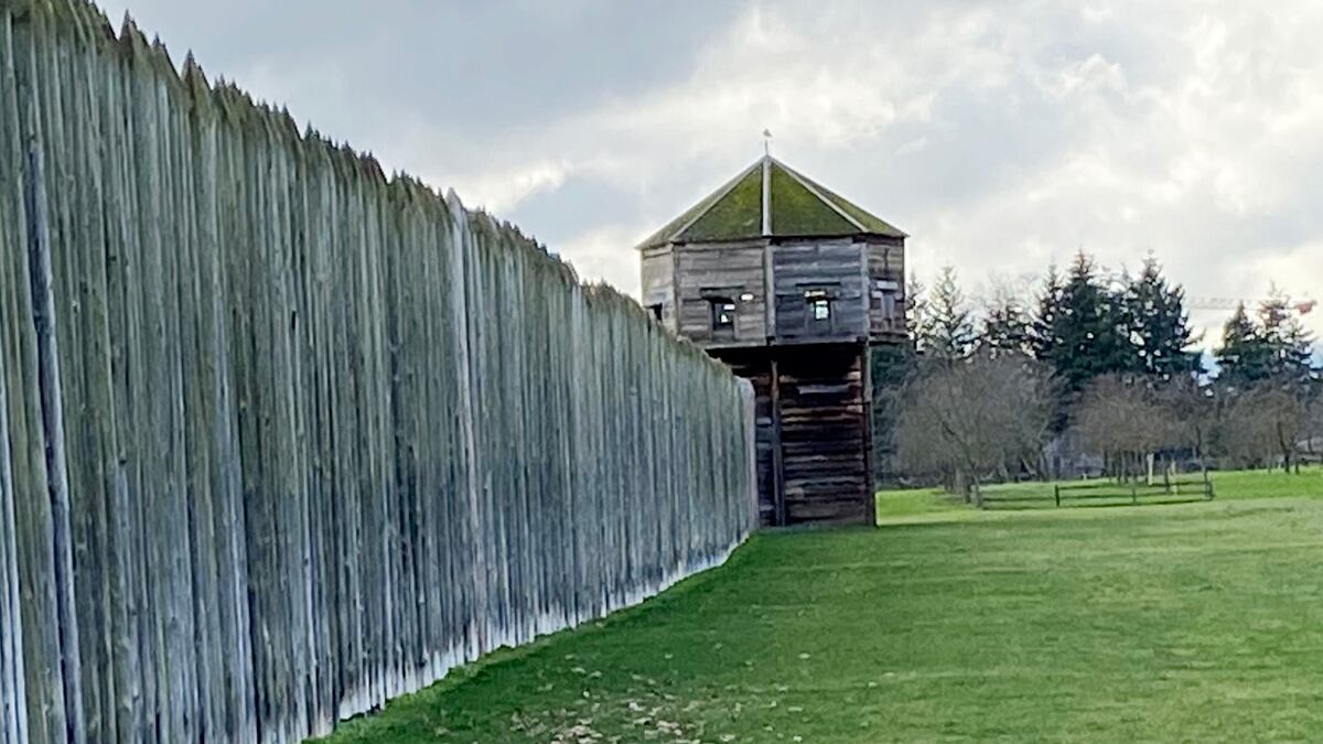
Located right near the city center, Fort Vancouver National Historic Site is a history nerd's dream hike. The 2.3-mile Discovery Historic Loop winds through the 366-acre park, which was home to a fur trading post in the 19th century. Though the visitor center, Pearson Air Museum, and reconstructed Fort Vancouver are temporarily closed due to the pandemic, the grounds are still open to explore. There are plenty of interpretative signs along the trail that explain the site's history. The easiest place to park is along East Evergreen Boulevard, which has off-street parking. From there you'll find the trail, where you'll see restored 19th century homes at Officers Row, Fort Vancouver and a large garden that includes many flowers and vegetable varieties from the time period. The trail also connects to Esther Short Park, the oldest public square in Washington. For a longer walk, you can combine this hike with the Columbia River Renaissance Trail by taking the bridge crossing, which has some interpretive signs as well. At the end of the bridge crossing you'll find Vancouver's Old Apple Tree. Planted in 1826, it is believed to be the oldest apple tree in the Northwest.
Directions: From I-5 north, take exit 1C-1D for WA-501/Mill Plain Blvd. Turn right onto Mill Plain and go 450 feet before turning right onto Fort Vancouver Way. At the traffic circle, take the third exit onto East Evergreen Boulevard. Parking spaces will be on your right.
Vancouver Lake
Less than a 15-minute drive from Vancouver's downtown, the trail along Vancouver Lake has everything you'd want in a nature walk: a lakeside park, pretty views, a beach and forest. You can also spend part of the day at Vancouver Lake Regional Park, which has picnic tables, barbecue grills and two volleyball courts (there's a $3 parking fee). If just hiking, park for free at the Blurock Landing Trailhead and take the Frenchman's Bar Trail toward Vancouver Lake Regional Park. The 4.5-mile out-and-back trail takes you through the southern part of the Shillapoo Wildlife Recreation Area, which also makes this a great hike for bird watching. Once you reach Vancouver Lake Regional Park, you can opt to take a short detour to the beach at Vancouver Lake, where you'll have views of Mounts Hood, Adams and St. Helens. Farther along the trail, you'll enter a quiet cottonwood forest. The trail continues through here for about another mile before it ends. From there, you'll go back the way you came to return to the trailhead.
Directions: From I-5 north, take exit 1C-1D for WA-501/Mill Plain Blvd. Keep right at the fork to continue on exit 1C and follow signs for WA-501/Mill Plain Blvd. Turn left onto East Mill Plain and, after almost 2 miles, continue onto West Fourth Plain Boulevard. After about 3 miles, keep right to continue on Northwest Lower River Road and you'll soon see the Blurock Landing Trailhead on your right.
Whipple Creek Regional Park
Whipple Creek Regional Park is actually located in Ridgefield, but it's worth the visit. The 300-acre park has 4.3 miles of trails that wind through a deep forest of huge Douglas firs and ferns. Trails are also open to mountain bikers. For a shorter hike, start at the Whipple Creek 21st Avenue North Trailhead. You can also begin at Fairgrounds Community Park for a longer trek, which has a public restroom and a playground. Added bonus: If you hike from here, you'll get a chance to see some horses. From the parking lot at Fairgrounds Community Park take the paved trail across the lawn and you'll find a connector trail to Whipple Creek Regional Park. You'll want to bear left at the two junctions as you walk the connector trail, which eventually crosses a footbridge and takes you to open farmlands. Keep following the trail and you'll cross the street before entering the gate for Whipple Creek Farms, where, as promised, you'll see horses grazing. Once you pass the farm, you'll enter Whipple Creek Regional Park, which has a network of trails to choose from, including dirt and gravel. If venturing on the gravel trails, be prepared to share them with horseback riders. During your hike, be sure to keep a lookout for some points of interest, which include the remains of an old grist mill from the 1960s and Custards' Chimney, a structure that used to be part of a house back in the 1930s.
Directions: From I-5 north, take exit 9 for Northeast 179th Street toward Battle Ground. Use the left two lanes to turn left onto 179th Street and then turn left onto Delfel Road. After almost a mile, turn right onto 164th Street and, after a half-mile, make a right into the driveway for Fairgrounds Community Park.