Oregon lawmakers from both parties are scrambling to respond to a sagebrush rebellion against a state-issued wildfire hazard map.
On Feb. 17, Republican lawmakers convened en masse in Salem to savage the map, the final version of which was published in January. The lawmakers took turns addressing the press from a dais bearing a sign that said “Repeal the Wildfire Hazard Map.”
Three hours before the GOP lawmakers convened, Gov. Tina Kotek issued a statement (on a federal holiday, no less) seeking to calm Oregonians who are appealing their properties’ designation on the map as “high hazard.”
Kotek said she was putting property owners’ appeals of the unwanted designation on hold until after the legislative session ends June 29. That way, if lawmakers decide to scrap the map—as its chief sponsor says they are likely to do—the appeals will be moot.
“Oregonians have raised concerns over the current Oregon Statewide Wildfire Hazard Map,” Kotek said. “This pause will allow for the transparent, public process required to address [it].”
Republicans say the wildfire hazard map is causing panic for many rural Oregonians who fear a “high hazard” designation would be financially disastrous for them. In essence, homeowners contend, the map serves as a guide showing insurance companies and banks which properties to avoid—a form of rural redlining. (Oregon law prohibits insurers from using the state map to determine whom they will insure, but it is a public record, visible to all.)
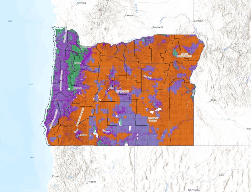
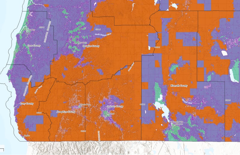
The map divides the state into three categories: low, moderate or high hazard. Much of rural Oregon is in the third category, colored red on the state map. Southern Oregon cities such as Medford and Ashland appear as small dots of green (low risk) surrounded by vast swatches, representing thousands of properties, colored red.
“The map is riddled with errors,” says state Sen. Noah Robinson (R-Cave Junction), “and insurance rates have skyrocketed, which is going to make it harder for people to get loans and sell property.”
Sen. Jeff Golden (D-Ashland), chief sponsor of the 2021 bill that created the wildfire hazard map, concedes the goal of drawing a blueprint to optimize the deployment of firefighting resources has gone badly off track. “The map has become such a distraction and so polarizing I think it needs to go,” Golden tells the Oregon Journalism Project.
Here, in three numbers, is the story of how lawmakers using a map got lost:
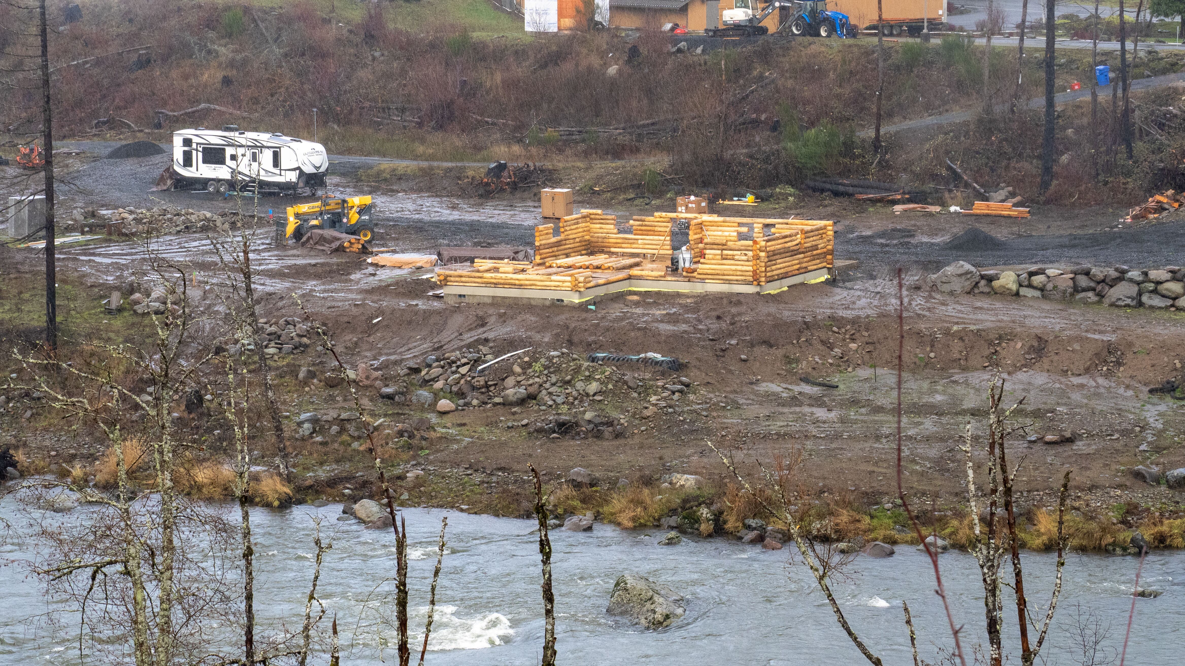
106,000: That’s how many Oregon households in what’s called the “wildland-urban interface” received notice Jan. 7 that the new map finalized in January categorizes their property as a “high hazard.” That designation would require homeowners to remove vegetation or take other steps to reduce wildfire risk. Property owners, particularly those in Jackson, Josephine and Deschutes counties, have inundated their lawmakers with complaints. “Rural Oregonians feel they are not being listened to,” says Sen. Robinson, who represents Josephine County. “I don’t think Democrats in Portland can understand what this is like.”
644: That’s how many Oregonians have filed appeals with the Oregon Department of Forestry, taking issue with their properties’ “high hazard” designation. The window for filing appeals remains open through March 10, but Kotek’s pause means the state will sit on them for now rather than referring them to the Office of Administrative Hearings.
3%: That is the percentage of wildfires that started and burned on private land from 2014 to 2023, according to Oregon Department of Forestry figures. In other words, the map puts the onus for wildfire prevention and mitigation on the wrong culprits, critics say. “The wildfire map places all the responsibility on private property owners while state and federal forest owners do nothing,” House Minority Leader Christine Drazan (R-Canby) told reporters Feb. 17.
This story was produced by the Oregon Journalism Project, a nonprofit newsroom covering rural Oregon. OJP seeks to inform, engage, and empower readers with investigative and watchdog reporting that makes an impact. Our stories appear in partner newspapers across the state.