If there is a peak that juts conspicuously into the skyline near the Oregon Coast, chances are good there's a well-worn trail leading to the top.
From the state's tallest sand dune in Pacific City to the prominent bald summit of Saddle Mountain, these mighty mounds of earth call to adventurers, promising the satisfaction that comes with conquering any thigh-burner.
But there is a hulking hill that dominates the view in the northern part of Lincoln City that, until recently, few people outside the local population knew was crisscrossed by a patchwork of paths leading to two stunning grassy overlooks and an impressive pinnacle called God's Thumb.
Why has the network of old road beds and trails sat largely undiscovered? The answer lies partially in the strange setting where you'll start this nearly 5-mile balloon. You wouldn't immediately know you're even at a trailhead upon arrival, since the road to get there dead-ends at a cul-de-sac nestled in a neighborhood of neatly poured sidewalks and houseless lots overgrown with vegetation. It's a scene from a post-apocalyptic sector of Lincoln City that officials seemingly forgot to cordon off.
The approximately 360-acre site is actually a failed development the city purchased for $2.5 million in 2013, which allowed for a trail easement and the posting of maps—albeit temporary, weathered and sometimes torn images at this point—to help keep visitors on the correct route and off private land.
Near the rear center of the cul-de-sac, you'll find an alcove leading into the forest and, after a couple hundred feet, the first of a handful of signs with illustrated directions, though many junctions remain unmarked. There's also an annotated list of some of the creatures that call the woods and meadows home, including coyotes, black-tailed deer and the Oregon silverspot—a threatened orange and brown butterfly with its namesake metallic color on the underside of its wings. If you look closely during this hike's stretches of open grassland, you're likely to catch sight of it.
But for the first mile or so, you'll be far too busy dodging muddy trenches that range from "gooey annoyance" to "ankle deep" even during a dry spell. Fortunately, as you continue along your ascent, the patches of muck disappear.
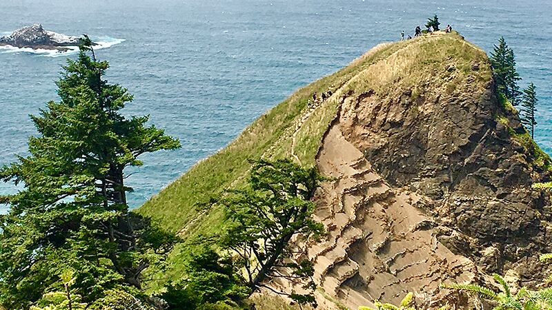
At the top of the ridge, you'll reach a fork. Veer right to get to God's Thumb. This is not a quick jaunt on a short spur to the hike's highlight. Instead, you've got to dig in for about one more mile, first plunging sharply into a darkened forest of spindly alders and stocky hemlock before pushing up into a salt-spray meadow. You're now standing on a seaside bluff that's regularly battered by high winds, which means only a few clusters of the hardiest trees can withstand the conditions. That leaves unobstructed views of Depoe Bay to the south on clear days and north to Cascade Head, a bulging cape carpeted in a similar shade of green that's almost like looking in a mirror at the land you're exploring.
The Thumb lies straight ahead—a sage-colored knob with a jagged brown cliff face that's as far out as you can get on this outcropping without tumbling into the ocean. Formed tens of millions of years ago, what's now a gnarled mound curving upward was originally part of a basalt dike. Waves will continue to whip away at the formation until, a few more million years from now, nothing but a sea stack should remain. If you decide to clamber up it, do so with an abundance of caution: A number of injuries have occurred at this spot.
With a spectacle so inspiring its name suggests that even the Almighty admires the view by extending an approving digit, any hiker would be happy to turn around here and call it a day. But there is one more location offering a different panorama: Once you've returned to the fork, hang a left and you'll quickly reach the Knoll, another grassy expanse where elk are known to make their beds at night. From here, the entire city is on display, including Devils Lake, which from the vantage point looks more like a pond.
As you take it in, think about the fact that for years, only locals knew how to get to such a beautiful place. Now you're in on their secret.
God’s Thumb and the Knoll
Distance: About 5 miles
Difficulty: *** out of ****
Drive time from Portland: 1 hour, 45 minutes
Directions: From Portland, head south on Interstate 5 and take exit 294 for Oregon 99W Tigard/Newberg. Continue on 99W for about 15 miles until you reach North Springbrook Road at Newberg's eastern end. Turn left there to reach the Oregon 18/Newberg-Dundee Bypass, then rejoin 99W/18. In a little more than 3 miles, veer left to stay on 18 and continue for 53 miles. Merge onto US 101 south and turn right onto Northeast Devils Lake Boulevard on the northern end of Lincoln City. You'll hit the cul-de-sac in a little more than a mile.