As if there already weren’t enough reasons to hit the road in Oregon, the state has something else besides natural marvels and kitschy attractions: some pretty amazing highway rest areas.
There are even some state parks that have a portion designated as a rest area. While we mainly stop by rest areas to, y’know, rest—stretch our legs and answer nature’s call—Oregon has several that are worth a longer visit, where, besides the basic amenities, you’ll find viewpoints, walking trails, and historical points of interest.
Here are several rest stops to explore next time you’re on the road.
Peter Skene Ogden State Scenic Viewpoint
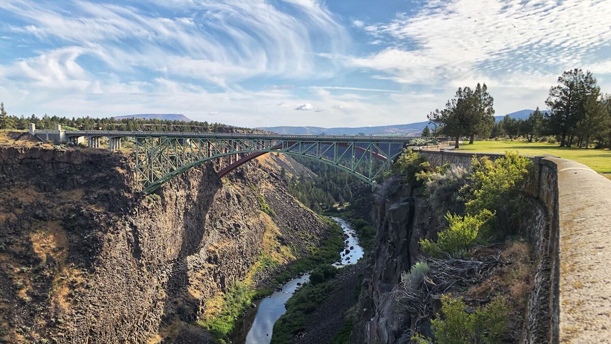
A must-stop if traveling toward Bend along Highway 97, the Peter Skene Ogden State Scenic Viewpoint, located in Terrebonne, is one of the most photographic rest stops in the state. It is named after explorer and fur trapper Peter Skene Ogden, who led several expeditions through the High Desert. The park features a walking path above basalt cliffs that drop 300 feet down into the Crooked River, along with three bridges that stretch across the canyon: the Crooked River Railroad Bridge, the Crooked River High Bridge and the Rex T. Barber Veterans Memorial Bridge.
Directions: From Interstate 84 east, take exit 14 for Fairview and turn right onto Fairview Parkway. Go almost 1 mile before turning left onto Northeast Glisan Street and then right onto 223rd Avenue. You’ll then make a quick left onto Northwest Fairview Drive and then another quick left onto Northeast Burnside Road. Drive 1.7 miles and continue straight onto US 26 east. After driving 104 miles, you’ll continue onto US 97 south. Drive another 15 miles before turning right into Peter Skene Ogden State Scenic Viewpoint.
Charles Reynolds Rest Area
The highlight at this rest stop along westbound I-84 has no relation to Charles Reynolds, who served on the Oregon State Highway Commission and was also president of the Old Oregon Trail Association for several years. Located about 35 miles west of Baker City, part of the rest area was once a ranch operated by William N. Banton, who settled there with his family in 1868. In 1911, Banton built a water-powered tool shop and operated on the land until he retired in 1940. The rustic water wheel and tool shop still stand as a reminder of simpler times. The stop also has a horse area, a vending machine and picnic tables.
Directions: On Interstate 84 east, drive 270 miles and take exit 273 toward Frontage Road. Swing left onto I-84 west and drive 4 miles before taking the exit for Charles Reynolds Rest Area.
Tillamook River Rest Area
A grassy rest stop just south of Tillamook along Highway 101, the Tillamook River Rest Area sits alongside the Tillamook River, complete with winding trails and lots of trees. The scenic rest area has even been used as a photo setting for weddings. Almost more like a park than a rest stop, it’s a great spot to score a free cup of coffee, sit by one of the picnic tables and contemplate life.
Directions: On US 26 west, drive about 20 miles before making a slight left onto OR 6 west toward Tillamook. You’ll drive about 50 miles before hitting US 101 south. Drive 3 miles and make a right into the Tillamook River Rest Area.
Sunset Rest Area
Just 45 miles west of Portland, Sunset Rest Area is a convenient stop while traveling on Sunset Highway toward the coast. However, in addition to the basic amenities, Sunset Rest Area’s short hiking trails provide opportunities to stretch your legs and take a walk through the Clatsop State Forest. Starting at the footbridge, cross over the South Fork Rock Creek, which connects you to the Springboard and Dooley Spur trails, a quiet forest loop that stretches almost a mile. There are also interpretive signs that describe the area’s logging history. Though a short trail, it’s a chance to take a necessary break from the road and commune with nature.
Directions: On US 26 west, drive 45 miles before turning right into the Sunset Rest Area.
French Prairie Rest Area
There are plenty of rest stops along the Interstate 5 corridor, but the French Prairie Rest Area, located in Aurora, has attractions on both sides of the highway. One of Oregon’s largest rest areas, French Prairie makes up over 40 acres on each side of the interstate. The Grove of States, located on the southbound side, features a short trail lined with trees representing the 50 states and island territories. Dedicated in 1967, the Grove of States is believed to be the oldest public arboretum of state trees in the country. If heading north, check out the state’s largest solar station, which includes a walking path with interpretive panels that describe the sustainable energy project.
Directions: On Interstate 5 south, drive about 14 miles before making a right into the French Prairie Rest Area.
Deadman Pass Rest Area
For those of us who grew up playing The Oregon Trail, there’s a rest area along Interstate 84 in Eastern Oregon that brings the nostalgic video game to life. Located 18 miles east of Pendleton, the Deadman Pass Rest Area has Oregon Trail wagon ruts that can be seen at the eastbound location. Located in the Blue Mountains, this was one of the most dangerous places along the Oregon Trail route. Heading back westward, take in some mountain views at the Deadman Pass Lookout Area.
Directions: On Interstate 84 east, drive 225 miles before taking exit 228 for Deadman Pass.